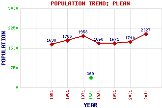
Plean Classification and Statistics Settlement Type: village Population (2011): 2027 (2001): 1740 (1991): 1671 (1981): 1668 (1971): 1953 (1961): 1785 (1951): 1639 (1881): 369 Tourist Rating: No Text of Entry Updated: 17-JUN-2007 Location Latitude: 56.0642°N Longitude: 3.8743°W National Grid Reference: NS 834 873 A range of modern and historical maps are accessible through the map tab on the right of this page Get directions by entering the UK postcode of your location, home or hotel here eg. EH1 3YT Use the tabs on the right of this page to see other parts of this entry Related Entries There are 20 related entries. (1 Attraction, 1 Council Area, 1 Historical County, 7 Features, 1 Parish, 0 People and 9 Settlements) Names that are not linked do not currently contain any information. Attractions: Dunblane Hydro Council Area: Stirling Features: A9 Trunk Road Bannockburn Hospital Bruce's Castle Glasgow-Perth Line Plane Castle Plean Station Tor Burn Historical Counties: Stirlingshire Parishes: St Ninians Settlements: Airth Auchenbowie Bannockburn Cowie Dunipace East Plean Fallin Torwood West Plean
There are 20 related entries. (1 Attraction, 1 Council Area, 1 Historical County, 7 Features, 1 Parish, 0 People and 9 Settlements)
Names that are not linked do not currently contain any information.
By using our site you agree to accept cookies, which help us serve you better