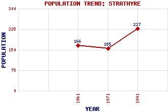
Strathyre Classification and Statistics Settlement Type: village Population (1991): 227 (1971): 155 (1961): 166 Tourist Rating: No Text of Entry Updated: 12-JUN-2007 Location Latitude: 56.3252°N Longitude: 4.3318°W National Grid Reference: NN 559 172 A range of modern and historical maps are accessible through the map tab on the right of this page Get directions by entering the UK postcode of your location, home or hotel here eg. EH1 3YT Use the tabs on the right of this page to see other parts of this entry Related Entries There are 25 related entries. (2 Attractions, 1 Council Area, 1 Historical County, 9 Features, 1 Parish, 1 Person and 10 Settlements) Names that are not linked do not currently contain any information. Attractions: Rob Roy Way Strathyre Council Area: Stirling Features: Balvag, River Beinn Bhreac Ben Our Ben Vorlich Cnoc Odhar Meall na Caora Meall na h-Iolaire Sgiath a' Chaise Voil, Loch Historical Counties: Perthshire Parishes: Balquhidder People: Robert (Rob Roy) MacGregor Settlements: Ardchullarie More Auchtoo Ballimore Balquhidder Callander Edinample Kilmahog Kingshouse Lochearnhead Stirling
There are 25 related entries. (2 Attractions, 1 Council Area, 1 Historical County, 9 Features, 1 Parish, 1 Person and 10 Settlements)
Names that are not linked do not currently contain any information.
By using our site you agree to accept cookies, which help us serve you better