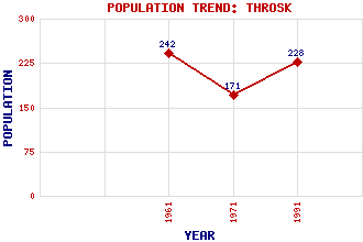
Throsk Classification and Statistics Settlement Type: hamlet Population (1991): 228 (1971): 171 (1961): 242 Tourist Rating: No Text of Entry Updated: 03-OCT-2002 Location Latitude: 56.0979°N Longitude: 3.8502°W National Grid Reference: NS 850 910 A range of modern and historical maps are accessible through the map tab on the right of this page Get directions by entering the UK postcode of your location, home or hotel here eg. EH1 3YT Use the tabs on the right of this page to see other parts of this entry Related Entries There are 10 related entries. (0 Attractions, 1 Council Area, 1 Historical County, 2 Features, 1 Parish, 1 Person and 4 Settlements) Names that are not linked do not currently contain any information. Council Area: Stirling Features: Bandeath Industrial Estate Forth, River Historical Counties: Stirlingshire Parishes: St Ninians People: Thomas Nelson(Thomas Neilson) Settlements: Cowie Dunmore Fallin South Alloa
There are 10 related entries. (0 Attractions, 1 Council Area, 1 Historical County, 2 Features, 1 Parish, 1 Person and 4 Settlements)
Names that are not linked do not currently contain any information.
By using our site you agree to accept cookies, which help us serve you better