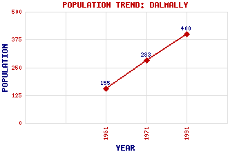
Dalmally Classification and Statistics Settlement Type: village Population (1991): 400 (1971): 283 (1961): 155 Tourist Rating: Text of Entry Updated: 15-JUN-2015 Location Latitude: 56.4001°N Longitude: 4.9847°W National Grid Reference: NN 159 271 A range of modern and historical maps are accessible through the map tab on the right of this page Get directions by entering the UK postcode of your location, home or hotel here eg. EH1 3YT References and Further Reading Walker, Frank Arneil (2000) The Buildings of Scotland: Argyll and Bute. Penguin, London Use the tabs on the right of this page to see other parts of this entry Related Entries There are 37 related entries. (4 Attractions, 1 Council Area, 1 Historical County, 21 Features, 1 Parish, 3 People and 6 Settlements) Names that are not linked do not currently contain any information. Attractions: Cruachan Power Station Kilchurn Castle Oban Branch West Highland Line Council Area: Argyll and Bute Features: Awe Viaduct Beinn Bhalgairean Beinn Bhreac Beinn Donachain Beinn Lurachan Beinn Mhic Mhonaidh Beinn na Sroine Ben Lui Bi, Lochan na Dalmally Railway Station Dhoireann, Lochan Eas Urchaidh Glen Shira Hydro Electric Scheme Lochy, River McLaren Monument Meall Garbh Orchy, Strath of Stob Diamh Stob Dubh Teatle Water t-Sithein, Allt an Historical Counties: Argyllshire Parishes: Glenorchy and Inishail People: Duncan Ban McIntyre(Donnchadh Ban Macant-Saoir) Duncan McLaren John Smith Settlements: Cladich Inverstrae Lochawe Oban Stronmilchan Tyndrum
There are 37 related entries. (4 Attractions, 1 Council Area, 1 Historical County, 21 Features, 1 Parish, 3 People and 6 Settlements)
Names that are not linked do not currently contain any information.
By using our site you agree to accept cookies, which help us serve you better