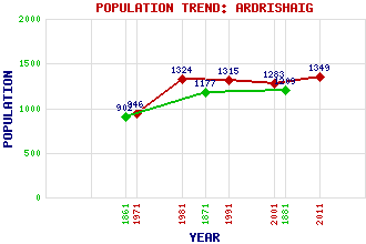
Ardrishaig Classification and Statistics Settlement Type: village Population (2011): 1349 (2001): 1283 (1991): 1315 (1981): 1324 (1971): 946 (1881): 1209 (1871): 1177 (1861): 902 Tourist Rating: Text of Entry Updated: 23-JUL-2015 Location Latitude: 56.0132°N Longitude: 5.4475°W National Grid Reference: NR 852 854 A range of modern and historical maps are accessible through the map tab on the right of this page Get directions by entering the UK postcode of your location, home or hotel here eg. EH1 3YT Use the tabs on the right of this page to see other parts of this entry Related Entries There are 23 related entries. (2 Attractions, 1 Council Area, 1 Historical County, 12 Features, 1 Parish, 3 People and 3 Settlements) Names that are not linked do not currently contain any information. Attractions: Argyll Sea Kayak Trail Crinan Canal Council Area: Argyll and Bute Features: Arail, Loch Beinn Bheag Brenfield Point Cruach Breacain Fyne, Loch Gilp, Loch Kilduskland Reservoir Knapdale Lussa, The Mid-Argyll Wemyss Bay Railway Station and Ferry Terminal Whitehouse Bay Historical Counties: Argyllshire Parishes: South Knapdale People: John Rennie Euphemia (Effie) Ritchie(Euphemia Thompson) John Smith Settlements: Achahoish Crinan Oban
There are 23 related entries. (2 Attractions, 1 Council Area, 1 Historical County, 12 Features, 1 Parish, 3 People and 3 Settlements)
Names that are not linked do not currently contain any information.
By using our site you agree to accept cookies, which help us serve you better