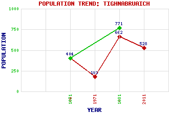
Tighnabruaich Classification and Statistics Settlement Type: village Population (2011): 528 (1981): 662(Combined with Kames) (1971): 181 (1961): 401 (1881): 771 (1871): 404 Tourist Rating: Text of Entry Updated: 26-OCT-2022 Location Latitude: 55.9066°N Longitude: 5.2331°W National Grid Reference: NR 980 729 A range of modern and historical maps are accessible through the map tab on the right of this page Get directions by entering the UK postcode of your location, home or hotel here eg. EH1 3YT Use the tabs on the right of this page to see other parts of this entry Related Entries There are 24 related entries. (1 Attraction, 1 Council Area, 1 Historical County, 11 Features, 1 Parish, 0 People and 9 Settlements) Names that are not linked do not currently contain any information. Attractions: St Michael's Chapel Council Area: Argyll and Bute Features: Acharossan Burn Beinn Bhreac Beinn Capuill Bute, Kyles of Clyde, Firth of Cowal Craignafeoch Reservoirs Riddon, Loch Tighnabruaich Pier Tighnabruaich Reservoir Torran Turach Historical Counties: Argyllshire Parishes: Kilfinan Settlements: Acharossan Ardlamont Auchenlochan Blair's Ferry Kames Kilfinan Lephinmore Port Driseach Portavadie
There are 24 related entries. (1 Attraction, 1 Council Area, 1 Historical County, 11 Features, 1 Parish, 0 People and 9 Settlements)
Names that are not linked do not currently contain any information.
By using our site you agree to accept cookies, which help us serve you better