Rothesay
Classification and Statistics
|
|
Location
|
Geography
Rothesay lies south of the Highland Boundary Fault which dissects the island and has given rise to craggy hills in the north and rich farmland to the south. Directly opposite the Ayrshire coast, Rothesay can be reached via a regular 35-minute car ferry from
Wemyss Bay on the Scottish mainland.
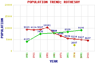
Rothesay accounts for 75% of the population of Bute and grew rapidly in the 18th century as a result of the success of fishing and manufacturing; its population rose from about 400 in 1756 to 2607 in 1790. This growth continued through the 19th C. owing to the town's development as a resort, reaching a peak of 10,141 in 1951 before beginning a steep decline. This decline led to unemployment and social problems, with parts of the town being identified as amongst the most deprived areas in Scotland as recently as 2013.
The town developed around Rothesay Bay, northwards to Port Bannatyne and to the east towards Bogany Point and beyond to Ascog, with grand waterfront hotels and guest houses for tourists, mansions for mainland industrialists and fine villas for sea-captains.
History
Established as a Royal Burgh in 1401 by
King Robert III, Rothesay has been a popular tourist resort since the early 19th century, expanding rapidly when Glasgow's growing working class were able to take trips 'doon the watter'.
Rothesay Castle, built in the early 12th Century, was the ancestral home of the Stuart Kings and the substantial ruins of this unique circular stronghold can still be seen in the centre of the town. There are many fine examples of Victorian architecture throughout the town: Glasgow-style tenements sit alongside earlier terraced cottages, which combine with the commercial heart of the town, esplanade, harbour and its other interesting individual buildings to form a vibrant townscape. Much of Rothesay is now a Conservation Area, which was designated in 1971, extended in 1980 and 1984 and given 'outstanding' status in 1985.
A tramway was laid in 1882, converted from horse-power to electricity in 1902, extended to the west coast of Bute in 1905 as the Rothesay and Ettrick Bay Light Railway, but closed in 1936.
Rothesay also served as a naval anchorage from 1940 to 1957, with submarines based here during World War II and training exercises centred here thereafter.
Industry
From the 17th century Rothesay benefited from the herring industry as a fishing port, with a New Quay added to the harbour 1785-90 but this declined from the 1850s. The form of the current harbour was established in the 1820s, when the earlier quays were rebuilt to accommodate steamers, and extended in 1867 and 1899 as traffic increased. Linen manufacture came in 1750 and the town gained one of the earliest cotton mills in Scotland when the Broadcroft Mill opened in 1778. This was using steam power by 1800, but the cost of coal during the Napoleonic Wars left the mills close to bankruptcy. However, the engineer
Robert Thom (1775 - 1847) proposed a new scheme based on water brought from
Loch Fad through aqueducts and cuts. The
Buteman newspaper was established in 1854 and still operates today. Electronics became an important employer when Flexible Technology began the production of specialist printed circuit boards in Rothesay in 1981. Further jobs come from the call-centre provider Telecom Service Centres, who have their headquarters here. Rothesay Creamery closed in 2010, bringing the production of the award-winning
Isle of Bute Cheddar to an end after 50 years. However it was to re-open two years later to make
sheese, a dairy-free vegan alternative to cheese.
References and Further Reading
McDowall, David (2010) Bute.
The Laird Press, Richmond, SurreySmith, Robin (2001) The Making of Scotland.
Canongate Books Ltd, EdinburghTranter, Nigel (1977) The Queen's Scotland: Argyll and Bute.
Hodder and Stoughton, LondonWalker, Frank Arneil, with Fiona Sinclair (1992) North Clyde Estuary: An Illustrated Architectural Guide.
The Royal Incorporation of Architects in Scotland, EdinburghWalker, Frank Arneil (2000) The Buildings of Scotland: Argyll and Bute.
Penguin, London
| Use the tabs on the right of this page to see other parts of this entry |
 |
Related Entries
There are 90 related entries.
(12 Attractions,
1 Council Area,
1 Historical County,
1 Event,
1 Family,
38 Features,
7 Parishes,
17 People and
12 Settlements)