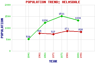
Helmsdale Classification and Statistics Settlement Type: village Population (1991): 828 (1981): 871 (1971): 727 (1961): 768 (1881): 1334 (1871): 1511 (1861): 1234 (1841): 526 Tourist Rating: Text of Entry Updated: 02-JUN-2010 Location Latitude: 58.1159°N Longitude: 3.6514°W National Grid Reference: ND 028 153 A range of modern and historical maps are accessible through the map tab on the right of this page Get directions by entering the UK postcode of your location, home or hotel here eg. EH1 3YT Use the tabs on the right of this page to see other parts of this entry Related Entries There are 35 related entries. (2 Attractions, 1 Council Area, 1 Historical County, 1 Family, 15 Features, 7 Parishes, 1 Person and 7 Settlements) Names that are not linked do not currently contain any information. Attractions: North Coast 500 Timespan Heritage Centre Council Area: Highland Families: Sutherland Features: A9 Trunk Road Ascaig, Loch Beinn Mhealaich Ben Uarie Borrobol Lodge Caithness Far North Line Helmsdale Golf Club Helmsdale Railway Station Helmsdale, River Moray Firth Morven Ord Point Ord of Caithness Sutherland Historical Counties: Sutherland Parishes: Clyne Farr Kildonan Kildonan Latheron Loth Wick People: Thomas Telford Settlements: Brora Kinbrace Navidale Portgower Torrish West Helmsdale Wick
There are 35 related entries. (2 Attractions, 1 Council Area, 1 Historical County, 1 Family, 15 Features, 7 Parishes, 1 Person and 7 Settlements)
Names that are not linked do not currently contain any information.
By using our site you agree to accept cookies, which help us serve you better