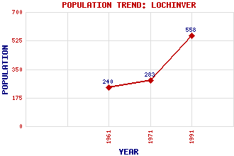
Lochinver Classification and Statistics Settlement Type: village Population (1991): 558 (1971): 283 (1961): 240 Tourist Rating: Text of Entry Updated: 31-JAN-2015 Location Latitude: 58.1501°N Longitude: 5.2404°W National Grid Reference: NC 094 225 A range of modern and historical maps are accessible through the map tab on the right of this page Get directions by entering the UK postcode of your location, home or hotel here eg. EH1 3YT Use the tabs on the right of this page to see other parts of this entry Related Entries There are 48 related entries. (5 Attractions, 1 Council Area, 1 Historical County, 1 Family, 28 Features, 1 Parish, 1 Person and 10 Settlements) Names that are not linked do not currently contain any information. Attractions: Assynt Leisure Centre Assynt Visitor Centre Culag Hotel Culag Woods Highland Stoneware Pottery Council Area: Highland Families: MacLeod Features: Achmelvich Bay Assynt Beannach, Loch Ben More Assynt Choire Ghuirm, Lochan a' Clashnessie Bay Conival Crocach, Loch Culag River Druim Suardalain, Loch Enard Bay Fionn Loch Fraochlan Gainimh, Loch na Inver, Loch Inver, River Inverpolly National Nature Reserve Ledmore Junction Mor, Eilean Mor, Rubha Oldany Island Soyea Island Stoer Peninsula Stoer, Bay of Stoer, Point of Suilven Sutherland Tuirc, Loch an Historical Counties: Sutherland Parishes: Assynt People: David Hutcheson Settlements: Achmelvich Achnacarnin Baddidarroch Badnaban Clachtoll Clashnessie Inchnadamph Kinlochbervie Stoer Ullapool
There are 48 related entries. (5 Attractions, 1 Council Area, 1 Historical County, 1 Family, 28 Features, 1 Parish, 1 Person and 10 Settlements)
Names that are not linked do not currently contain any information.
By using our site you agree to accept cookies, which help us serve you better