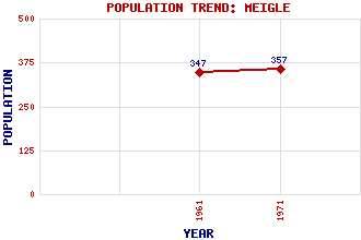
Meigle Classification and Statistics Settlement Type: village Population (1971): 357 (1961): 347 Tourist Rating: Text of Entry Updated: 10-FEB-2007 Location Latitude: 56.5878°N Longitude: 3.1625°W National Grid Reference: NO 287 446 A range of modern and historical maps are accessible through the map tab on the right of this page Get directions by entering the UK postcode of your location, home or hotel here eg. EH1 3YT Use the tabs on the right of this page to see other parts of this entry Related Entries There are 19 related entries. (2 Attractions, 1 Council Area, 1 Historical County, 5 Features, 1 Parish, 1 Person and 8 Settlements) Names that are not linked do not currently contain any information. Attractions: Macbeth's Stone Meigle Sculptured Stone Museum, The Council Area: Perth and Kinross Features: Arthurstone House Belmont Castle Dean Water Drumkilbo Jordanstone House Historical Counties: Perthshire Parishes: Meigle People: Sir Henry Campbell-Bannerman Settlements: Balkeerie Kinloch Kirkinch Leitfie Longleys Nevay Newbigging Ruthven
There are 19 related entries. (2 Attractions, 1 Council Area, 1 Historical County, 5 Features, 1 Parish, 1 Person and 8 Settlements)
Names that are not linked do not currently contain any information.
By using our site you agree to accept cookies, which help us serve you better