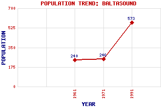
Baltasound Classification and Statistics Settlement Type: village Population (1991): 573 (1971): 246 (1961): 240 Tourist Rating: No Text of Entry Updated: 18-FEB-2015 Location Latitude: 60.7574°N Longitude: 0.8623°W National Grid Reference: HP 621 088 A range of modern and historical maps are accessible through the map tab on the right of this page Get directions by entering the UK postcode of your location, home or hotel here eg. EH1 3YT Use the tabs on the right of this page to see other parts of this entry Related Entries There are 29 related entries. (3 Attractions, 1 Council Area, 1 Historical County, 18 Features, 1 Parish, 0 People and 5 Settlements) Names that are not linked do not currently contain any information. Attractions: Hagdale Horse Mill Unst Bus Shelter Unst Leisure Centre Council Area: Shetland Features: Balta Baltasound Junior High School Caldback, Hill of Colvadale, Hill of Crussa Field Hevda Hill Keen of Hamar, The Little Heog Muckle Heog Nikka Vord Nor Wick RAF Saxa Vord Sand Wick Shetland College UHI Unst Unst Airport Watlee, Loch of Woodwick, Dale of Historical Counties: Shetland Parishes: Unst Settlements: Buness Burrafirth Hamar Haroldswick Houlland
There are 29 related entries. (3 Attractions, 1 Council Area, 1 Historical County, 18 Features, 1 Parish, 0 People and 5 Settlements)
Names that are not linked do not currently contain any information.
By using our site you agree to accept cookies, which help us serve you better