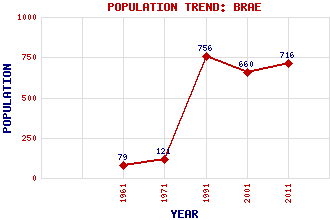
Brae Classification and Statistics Settlement Type: hamlet Population (2011): 716 (2001): 660 (1991): 756 (1971): 121 (1961): 79 Tourist Rating: No Text of Entry Updated: 05-MAY-2013 Location Latitude: 60.397°N Longitude: 1.3522°W National Grid Reference: HU 358 683 A range of modern and historical maps are accessible through the map tab on the right of this page Get directions by entering the UK postcode of your location, home or hotel here eg. EH1 3YT Use the tabs on the right of this page to see other parts of this entry Related Entries There are 40 related entries. (1 Attraction, 1 Council Area, 1 Historical County, 19 Features, 12 Parishes, 0 People and 6 Settlements) Names that are not linked do not currently contain any information. Attractions: North Mainland Leisure Centre Council Area: Shetland Features: Brae High School Burravoe, Hill of Busta Voe Button Hills Dalescord Hill Duddin Hill Gallow Hill Garths Voe Haggrister, Bight of Hardwall, Hill of Houb of Scatsta Olna Firth Orka Voe Scatsta, Hill of Scatsta, Voe of Sullom Voe Sullom Voe Terminal Voxter Ness Voxter Voe Historical Counties: Shetland Parishes: Bressay Delting Dunrossness Fetlar Lerwick Nesting Northmaven Sandsting Tingwall Unst Walls and Sandness Yell Settlements: Burravoe Busta Housetter Lerwick Mangaster Wethersta
There are 40 related entries. (1 Attraction, 1 Council Area, 1 Historical County, 19 Features, 12 Parishes, 0 People and 6 Settlements)
Names that are not linked do not currently contain any information.
By using our site you agree to accept cookies, which help us serve you better