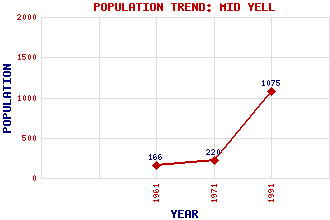
Mid Yell Classification and Statistics Settlement Type: settlement Population (1991): 1075 (1971): 220 (1961): 166 Tourist Rating: No Text of Entry Updated: 18-FEB-2007 Location Latitude: 60.5982°N Longitude: 1.0669°W National Grid Reference: HU 512 909 A range of modern and historical maps are accessible through the map tab on the right of this page Get directions by entering the UK postcode of your location, home or hotel here eg. EH1 3YT Use the tabs on the right of this page to see other parts of this entry Related Entries There are 22 related entries. (1 Attraction, 1 Council Area, 1 Historical County, 15 Features, 1 Parish, 0 People and 3 Settlements) Names that are not linked do not currently contain any information. Attractions: Yell Leisure Centre Council Area: Shetland Features: Bouster, Hill of Camb, Hill of Head, The Kay Holm Lussetter, Hill of Lussetter, Ness of Mid Yell Junior High School Mid Yell Voe North Aywick, Loch of Setter, Hill of Shetland Mainland South Sound Southladie Voe Unst Whale Firth Historical Counties: Shetland Parishes: Yell Settlements: Colvister Gutcher Ulsta
There are 22 related entries. (1 Attraction, 1 Council Area, 1 Historical County, 15 Features, 1 Parish, 0 People and 3 Settlements)
Names that are not linked do not currently contain any information.
By using our site you agree to accept cookies, which help us serve you better