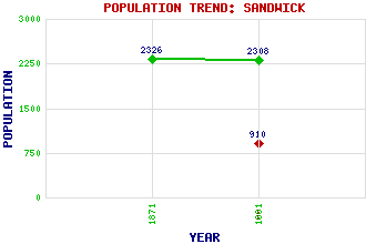
Sandwick Classification and Statistics Settlement Type: settlement Population (1991): 910 (1881): 2308 (1871): 2326 Tourist Rating: No Text of Entry Updated: 17-JUN-2012 Location Latitude: 59.9958°N Longitude: 1.2256°W National Grid Reference: HU 433 237 A range of modern and historical maps are accessible through the map tab on the right of this page Get directions by entering the UK postcode of your location, home or hotel here eg. EH1 3YT Use the tabs on the right of this page to see other parts of this entry Related Entries There are 20 related entries. (2 Attractions, 1 Council Area, 1 Historical County, 9 Features, 1 Parish, 0 People and 6 Settlements) Names that are not linked do not currently contain any information. Attractions: Broch of Mousa South Mainland Leisure Centre Council Area: Shetland Features: Cumlewick Ness Dunrossness Kirk Mousa No Ness Sand Wick Sandwick Junior High School Shetland Mainland South Mainland Ward of Burraland Historical Counties: Shetland Parishes: Dunrossness Settlements: Hoswick Houlland Leebotten Lerwick Noness Stove
There are 20 related entries. (2 Attractions, 1 Council Area, 1 Historical County, 9 Features, 1 Parish, 0 People and 6 Settlements)
Names that are not linked do not currently contain any information.
By using our site you agree to accept cookies, which help us serve you better