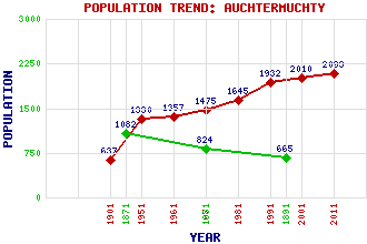
Auchtermuchty Classification and Statistics Settlement Type: village Population (2011): 2093 (2001): 2010 (1991): 1932 (1981): 1645 (1971): 1475 (1961): 1357 (1951): 1330 (1901): 637(Royal and Municipal Burgh) (1891): 665(For Royal Burgh) (1881): 824(For Royal Burgh) (1871): 1082(For Royal Burgh) Tourist Rating: Text of Entry Updated: 28-JUL-2009 Location Latitude: 56.2924°N Longitude: 3.2343°W National Grid Reference: NO 237 118 A range of modern and historical maps are accessible through the map tab on the right of this page Get directions by entering the UK postcode of your location, home or hotel here eg. EH1 3YT Use the tabs on the right of this page to see other parts of this entry Related Entries There are 27 related entries. (5 Attractions, 1 Council Area, 1 Historical County, 1 Family, 6 Features, 1 Parish, 6 People and 6 Settlements) Names that are not linked do not currently contain any information. Attractions: Auchtermuchty Parish Church Auchtermuchty Town House Boar's Head Inn Liniclate Community School Macduff House Council Area: Fife Families: Myers Features: Howe of Fife Myres Castle Pitlour Hill Pitmedden Forest Rossie House Weddersbie Hill Historical Counties: Fife Parishes: Auchtermuchty People: Reginald Francis Joseph Fairlie John Glass Captain George Moodie Charles (Charlie) Reid Craig Reid Sir James (Jimmy) Shand Settlements: Cupar Dunshalt Grange of Lindores Newburgh Pleasance Rossie
There are 27 related entries. (5 Attractions, 1 Council Area, 1 Historical County, 1 Family, 6 Features, 1 Parish, 6 People and 6 Settlements)
Names that are not linked do not currently contain any information.
By using our site you agree to accept cookies, which help us serve you better