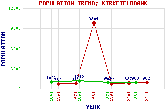
Kirkfieldbank Classification and Statistics Settlement Type: village Population (2011): 962 (2001): 887 (1991): 770 (1981): 9804(Combined with Lanark) (1971): 811 (1961): 782 (1881): 963 (1871): 963 (1861): 1212 (1841): 1023 Tourist Rating: No Text of Entry Updated: 29-JUL-2023 Location Latitude: 55.6744°N Longitude: 3.8047°W National Grid Reference: NS 866 438 A range of modern and historical maps are accessible through the map tab on the right of this page Get directions by entering the UK postcode of your location, home or hotel here eg. EH1 3YT Use the tabs on the right of this page to see other parts of this entry Related Entries There are 12 related entries. (2 Attractions, 1 Council Area, 1 Historical County, 3 Features, 1 Parish, 2 People and 2 Settlements) Names that are not linked do not currently contain any information. Attractions: Clyde Valley Stonebyres Linn Council Area: South Lanarkshire Features: Clyde, Falls of Clyde, River Mouse Water Historical Counties: Lanarkshire Parishes: Lanark People: Alasdair Gray Robert McLellan Settlements: Lanark New Lanark
There are 12 related entries. (2 Attractions, 1 Council Area, 1 Historical County, 3 Features, 1 Parish, 2 People and 2 Settlements)
Names that are not linked do not currently contain any information.
By using our site you agree to accept cookies, which help us serve you better