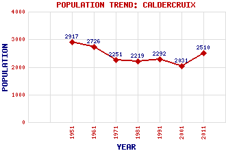
Caldercruix Classification and Statistics Settlement Type: village Population (2011): 2510 (2001): 2031 (1991): 2292 (1981): 2219 (1971): 2251 (1961): 2726 (1951): 2917 Tourist Rating: N/A Text of Entry Updated: 22-MAR-2012 Location Latitude: 55.8906°N Longitude: 3.8867°W National Grid Reference: NS 821 680 A range of modern and historical maps are accessible through the map tab on the right of this page Get directions by entering the UK postcode of your location, home or hotel here eg. EH1 3YT Use the tabs on the right of this page to see other parts of this entry Related Entries There are 15 related entries. (0 Attractions, 1 Council Area, 1 Historical County, 8 Features, 1 Parish, 0 People and 4 Settlements) Names that are not linked do not currently contain any information. Council Area: North Lanarkshire Features: Airdrie-Bathgate Railway Avon, River Cairneyhill Quarry Caldercruix Railway Station Hillend Reservoir Lilly Loch Moffat Hills North Calder Water Historical Counties: Lanarkshire Parishes: New Monkland Settlements: Airdrie Avonhead Plains Slamannan
There are 15 related entries. (0 Attractions, 1 Council Area, 1 Historical County, 8 Features, 1 Parish, 0 People and 4 Settlements)
Names that are not linked do not currently contain any information.
By using our site you agree to accept cookies, which help us serve you better