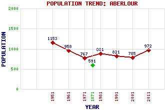
Aberlour (Charlestown of Aberlour) Classification and Statistics Settlement Type: village Population (2011): 972 (2001): 785 (1991): 821 (1981): 881 (1971): 767 (1961): 958 (1951): 1153 (1871): 591 Tourist Rating: Text of Entry Updated: 03-OCT-2002 Location Latitude: 57.4704°N Longitude: 3.2254°W National Grid Reference: NJ 266 429 A range of modern and historical maps are accessible through the map tab on the right of this page Get directions by entering the UK postcode of your location, home or hotel here eg. EH1 3YT Use the tabs on the right of this page to see other parts of this entry Related Entries There are 35 related entries. (5 Attractions, 1 Council Area, 1 Historical County, 3 Families, 15 Features, 1 Parish, 3 People and 6 Settlements) Names that are not linked do not currently contain any information. Attractions: Aberlour Distillery Cragganmore Distillery Macallan Distillery Speyside Way Speyside Way Visitor Centre Council Area: Moray Families: Fleming Grant Jupp Features: Aberlour, Burn of Allachie, Knock of Blue Hill Broomhill Railway Station Buchromb, Knock of Edinvillie, Daugh of Gheallaidh, Allt a' Gordonstoun School Kinermony, Daugh of Paul's Hill Wind Farm Ruthrie, Linn of Spey, River Speyside High School Strathspey Victoria Bridge Historical Counties: Moray Parishes: Knockando People: Saint Drostan(St. Drostan) John Ritchie Findlay Joseph Walker Settlements: Archiestown Craigellachie Dufftown Elgin Marypark Milltown of Edinvillie
There are 35 related entries. (5 Attractions, 1 Council Area, 1 Historical County, 3 Families, 15 Features, 1 Parish, 3 People and 6 Settlements)
Names that are not linked do not currently contain any information.
By using our site you agree to accept cookies, which help us serve you better