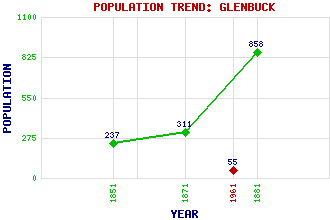
Glenbuck Classification and Statistics Settlement Type: locality Population (1961): 55 (1881): 858 (1871): 311 (1851): 237 Tourist Rating: No Text of Entry Updated: 27-FEB-2017 Location Latitude: 55.543°N Longitude: 3.9857°W National Grid Reference: NS 748 295 A range of modern and historical maps are accessible through the map tab on the right of this page Get directions by entering the UK postcode of your location, home or hotel here eg. EH1 3YT Use the tabs on the right of this page to see other parts of this entry Related Entries There are 15 related entries. (0 Attractions, 1 Council Area, 1 Historical County, 9 Features, 1 Parish, 1 Person and 2 Settlements) Names that are not linked do not currently contain any information. Council Area: East Ayrshire Features: Auchendaff Hill Galawhistle Burn Galawhistle Wind Farm Glenbuck Loch Glenbuck Water Hareshaw Hill Nethan, River Wether Hill Wetherhill Cairn Historical Counties: Ayrshire Parishes: Muirkirk People: William (Bill) Shankly Settlements: Muirkirk Spireslack
There are 15 related entries. (0 Attractions, 1 Council Area, 1 Historical County, 9 Features, 1 Parish, 1 Person and 2 Settlements)
Names that are not linked do not currently contain any information.
By using our site you agree to accept cookies, which help us serve you better