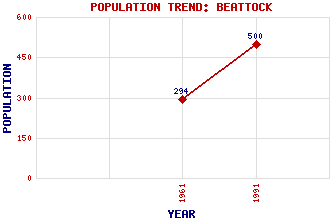
Beattock Classification and Statistics Settlement Type: village Population (1991): 500 (1961): 294 Tourist Rating: Text of Entry Updated: 06-MAY-2019 Location Latitude: 55.3056°N Longitude: 3.4504°W National Grid Reference: NT 080 022 A range of modern and historical maps are accessible through the map tab on the right of this page Get directions by entering the UK postcode of your location, home or hotel here eg. EH1 3YT Use the tabs on the right of this page to see other parts of this entry Related Entries There are 35 related entries. (3 Attractions, 1 Council Area, 1 Historical County, 24 Features, 1 Parish, 1 Person and 4 Settlements) Names that are not linked do not currently contain any information. Attractions: Annandale Way Auchen Castle Southern Upland Way Council Area: Dumfries and Galloway Features: Annandale Auchencastle Beattock Hill Beattock Summit Black Hill Craighoar Hill Earshaigs Evan Water Garpol Water Hareshaw Rig Harestanes Heights Holehouse Hill Killyminshaw Hill Lamb Hill Laverhay Height Milne Height Minnygap Height Mount Haul Muir Hill Penbreck Pot Hill Queensberry Wardlaw Wee Queensberry Historical Counties: Dumfriesshire Parishes: Kirkpatrick-Juxta People: Thomas Telford Settlements: Dumfries Glasgow Moffat Newton Wamphray
There are 35 related entries. (3 Attractions, 1 Council Area, 1 Historical County, 24 Features, 1 Parish, 1 Person and 4 Settlements)
Names that are not linked do not currently contain any information.
By using our site you agree to accept cookies, which help us serve you better