Gazetteer
for
Scotland

Help
Glossary

Map of Aberdeenshire

Any Word
People
Places
Statistics

Member's Area
Add Comment

Click for Bookshop

Strichen

Classification and Statistics

Settlement Type: village
Population (2001): 879    
(1991): 1112
(1981): 892
(1971): 962
(1961): 967
(1951): 1040
(1891): 1133
(1881): 1204
(1871): 1184
(1861): 1030

Tourist Rating: N/A
Text of Entry Updated: 06-SEP-2007
Location

Latitude: 57.585°N Longitude: 2.0936°W
National Grid Reference: NJ 945 550
Show Maps:          
Get directions by entering the UK postcode of your location, home or hotel here eg. EH1 3YT
 

History

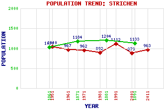
The population of the new village expanded to 200 in 1790 and 681 in 1840, a boost to development later taking place when the railway arrived in 1865. The two-storey Town Hall in the centre of the village dates from 1816 and the public library in the Anderson and Woodman Institute was opened in 1923. The Parish Church was originally built as a Free Church in 1893 and replaced an older building within the churchyard to the south west of the village on the union of the Free Church with the Church of Scotland in 1929. The older building which dates from 1798 was the successor to an earlier church built in 1620. Also in the old kirkyard is the Tolquhon Tomb which was created in 1589 for William Forbes of Tolquhon Castle and his wife Elizabeth Gordon. Other church buildings in Strichen include an Episcopal Church (1861) and a building thought to have been built in 1580 as a Roman Catholic chapel but never completed. Nearly a mile to the south of the village is a a recumbent stone circle which dates from the 3rd-2nd millennium BC.

Use the tabs on the right of this page to see other parts of this entry


Related Entries

There are 18 related entries.

( 3 Attractions, 1 Council Area, 1 Historical County, 4 Families, 4 Features, 1 Parish, 1 Person and 3 Settlements )

Names that are not linked do not currently contain any information.

Attractions:
  • Strichen Stone Circle
Council Area:
Families:
Features:
Historical Counties:
Parishes:
People:
Settlements:

Overview
Details
Historical
Map
No Photographs
No Sounds
No Video
No User Comments
Linked Information
If you have found this information useful please consider making
a donation to help maintain and improve this resource. More info...
©2011 The Editors of The Gazetteer for Scotland
Supported by: The Robertson Trust,  The Royal Scottish Geographical Society,
  School of GeoSciences, University of Edinburgh.