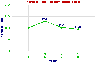
Dunnichen Classification and Statistics Settlement Type: hamlet Population (1881): 1422 (1871): 1536 (1861): 1932 (1831): 1513 Tourist Rating: Text of Entry Updated: 20-JUN-2005 Location Latitude: 56.6167°N Longitude: 2.8016°W National Grid Reference: NO 509 475 A range of modern and historical maps are accessible through the map tab on the right of this page Get directions by entering the UK postcode of your location, home or hotel here eg. EH1 3YT Use the tabs on the right of this page to see other parts of this entry Related Entries There are 15 related entries. (0 Attractions, 1 Council Area, 1 Historical County, 2 Features, 1 Parish, 3 People and 7 Settlements) Names that are not linked do not currently contain any information. Council Area: Angus Features: Dunnichen Hill Nechtansmere Historical Counties: Angus Parishes: Dunnichen People: Saint Constantine(St. Constantine; St. Causnan) George Dempster of Dunnichen(Honest George) Admiral Adam Duncan(1st Viscount Camperdown) Settlements: Bowriefauld Burnside Craichie Dundee Forfar Letham Stanley
There are 15 related entries. (0 Attractions, 1 Council Area, 1 Historical County, 2 Features, 1 Parish, 3 People and 7 Settlements)
Names that are not linked do not currently contain any information.
By using our site you agree to accept cookies, which help us serve you better