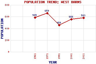
West Barns Classification and Statistics Settlement Type: village Population (2011): 583 (2001): 555 (1991): 459 (1971): 659 (1961): 585 Tourist Rating: N/A Text of Entry Updated: 20-JUN-2002 Location Latitude: 55.9946°N Longitude: 2.553°W National Grid Reference: NT 656 781 A range of modern and historical maps are accessible through the map tab on the right of this page Get directions by entering the UK postcode of your location, home or hotel here eg. EH1 3YT Use the tabs on the right of this page to see other parts of this entry Related Entries There are 10 related entries. (2 Attractions, 1 Council Area, 1 Historical County, 3 Features, 1 Parish, 0 People and 2 Settlements) Names that are not linked do not currently contain any information. Attractions: East Links Family Park John Muir Country Park Council Area: East Lothian Features: Belhaven Bay Biel Water East Coast Main Line Historical Counties: East Lothian Parishes: Dunbar Settlements: Belhaven Dunbar
There are 10 related entries. (2 Attractions, 1 Council Area, 1 Historical County, 3 Features, 1 Parish, 0 People and 2 Settlements)
Names that are not linked do not currently contain any information.
By using our site you agree to accept cookies, which help us serve you better