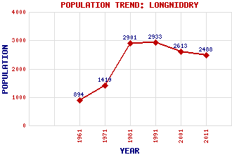
Longniddry Classification and Statistics Settlement Type: village Population (2011): 2488 (2001): 2613 (1991): 2933 (1981): 2901 (1971): 1419 (1961): 894 Tourist Rating: Text of Entry Updated: 07-NOV-2011 Location Latitude: 55.9737°N Longitude: 2.8972°W National Grid Reference: NT 441 760 A range of modern and historical maps are accessible through the map tab on the right of this page Get directions by entering the UK postcode of your location, home or hotel here eg. EH1 3YT Use the tabs on the right of this page to see other parts of this entry Related Entries There are 31 related entries. (2 Attractions, 1 Council Area, 1 Historical County, 1 Family, 14 Features, 1 Parish, 2 People and 9 Settlements) Names that are not linked do not currently contain any information. Attractions: John Muir Way Raceland Karting Centre Council Area: East Lothian Families: Wemyss Features: Amisfield Park Canty Burn East Coast Main Line Ferny Ness Fernyness Wood Gosford House Kilspindie Golf Club Longniddry Bents Longniddry Dean Longniddry Golf Club Longniddry Railway Station Redhouse Castle Seton Dean Seton Sands Historical Counties: East Lothian Parishes: Gladsmuir People: Robert Adam Mollie Hunter(Maureen Mollie Hunter Mcllwraith) Settlements: Aberlady Cockenzie Cockenzie and Port Seton Elvingston Gladsmuir Port Seton Seton Mains Spittal Tranent
There are 31 related entries. (2 Attractions, 1 Council Area, 1 Historical County, 1 Family, 14 Features, 1 Parish, 2 People and 9 Settlements)
Names that are not linked do not currently contain any information.
By using our site you agree to accept cookies, which help us serve you better