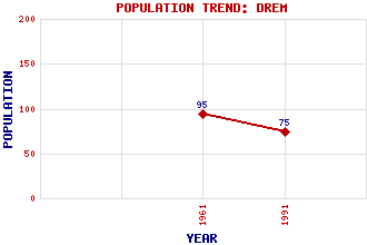
Drem Classification and Statistics Settlement Type: hamlet Population (1991): 75 (1961): 95 Tourist Rating: N/A Text of Entry Updated: 12-AUG-2017 Location Latitude: 56.006°N Longitude: 2.7883°W National Grid Reference: NT 509 795 A range of modern and historical maps are accessible through the map tab on the right of this page Get directions by entering the UK postcode of your location, home or hotel here eg. EH1 3YT Use the tabs on the right of this page to see other parts of this entry Related Entries There are 20 related entries. (4 Attractions, 1 Council Area, 1 Historical County, 1 Event, 4 Features, 1 Parish, 1 Person and 7 Settlements) Names that are not linked do not currently contain any information. Attractions: Chesters Hill Fort Museum of Flight, The Myreton Motor Museum Scottish Archery Centre, The Council Area: East Lothian Events: First Air Raid of World War II Features: Drem Railway Station East Coast Main Line Edinburgh Airport Rosyth, Port of Historical Counties: East Lothian Parishes: Athelstaneford People: James Scott Reid(Lord Reid of Drem) Settlements: Aberlady Athelstaneford Camptoun Fenton Barns Haddington Mungoswells North Berwick
There are 20 related entries. (4 Attractions, 1 Council Area, 1 Historical County, 1 Event, 4 Features, 1 Parish, 1 Person and 7 Settlements)
Names that are not linked do not currently contain any information.
By using our site you agree to accept cookies, which help us serve you better