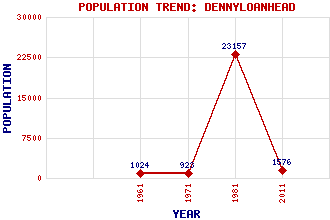
Dennyloanhead Classification and Statistics Settlement Type: village Population (2011): 1576 (1981): 23157(Combined with Denny) (1971): 923 (1961): 1024 Tourist Rating: No Text of Entry Updated: 03-FEB-2023 Location Latitude: 55.999°N Longitude: 3.9096°W National Grid Reference: NS 810 801 A range of modern and historical maps are accessible through the map tab on the right of this page Get directions by entering the UK postcode of your location, home or hotel here eg. EH1 3YT Use the tabs on the right of this page to see other parts of this entry Related Entries There are 11 related entries. (0 Attractions, 1 Council Area, 1 Historical County, 2 Features, 1 Parish, 0 People and 6 Settlements) Names that are not linked do not currently contain any information. Council Area: Falkirk Features: Bonny Water M876 Motorway Historical Counties: Stirlingshire Parishes: Denny Settlements: Allandale Bonnybridge Denny Kilsyth Longcroft Muir, Head of
There are 11 related entries. (0 Attractions, 1 Council Area, 1 Historical County, 2 Features, 1 Parish, 0 People and 6 Settlements)
Names that are not linked do not currently contain any information.
By using our site you agree to accept cookies, which help us serve you better