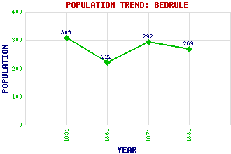
Bedrule Classification and Statistics Settlement Type: hamlet Population (1881): 269 (1871): 292 (1861): 222 (1831): 309 Tourist Rating: N/A Text of Entry Updated: 01-AUG-2016 Location Latitude: 55.4542°N Longitude: 2.6308°W National Grid Reference: NT 602 180 A range of modern and historical maps are accessible through the map tab on the right of this page Get directions by entering the UK postcode of your location, home or hotel here eg. EH1 3YT Use the tabs on the right of this page to see other parts of this entry Related Entries There are 20 related entries. (1 Attraction, 1 Council Area, 1 Historical County, 1 Family, 8 Features, 1 Parish, 3 People and 4 Settlements) Names that are not linked do not currently contain any information. Attractions: Borders Abbeys Way Council Area: Scottish Borders Families: Usher Features: Bedrule Castle Fulton Tower Hallrule Rubers Law Rule Water Spittal Tower Teviotdale University of Glasgow Historical Counties: Roxburghshire Parishes: Bedrule People: Lieutenant Anthony (Tony) Fasson (Robert) Douglas Strachan Sir John Usher(Sir John Usher of Norton) Settlements: Edinburgh Hallrule Jedburgh Wells
There are 20 related entries. (1 Attraction, 1 Council Area, 1 Historical County, 1 Family, 8 Features, 1 Parish, 3 People and 4 Settlements)
Names that are not linked do not currently contain any information.
By using our site you agree to accept cookies, which help us serve you better