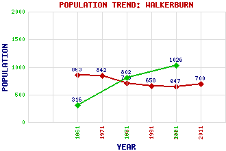
Walkerburn Classification and Statistics Settlement Type: village Population (2011): 700 (2001): 647 (1991): 658 (1981): 713 (1971): 842 (1961): 863 (1881): 1026 (1871): 802 (1861): 316 Tourist Rating: N/A Text of Entry Updated: 17-APR-2010 Location Latitude: 55.6232°N Longitude: 3.0178°W National Grid Reference: NT 360 371 A range of modern and historical maps are accessible through the map tab on the right of this page Get directions by entering the UK postcode of your location, home or hotel here eg. EH1 3YT Use the tabs on the right of this page to see other parts of this entry Related Entries There are 12 related entries. (2 Attractions, 1 Council Area, 1 Historical County, 5 Features, 1 Parish, 1 Person and 1 Settlement) Names that are not linked do not currently contain any information. Attractions: Scottish Museum of Woollen Textiles Traquair House Council Area: Scottish Borders Features: Dunlee Hill Great Law Minch Moor Tweed, River Yardstone Knowe Historical Counties: Peeblesshire Parishes: Innerleithen People: Frederick Thomas Pilkington Settlements: Innerleithen
There are 12 related entries. (2 Attractions, 1 Council Area, 1 Historical County, 5 Features, 1 Parish, 1 Person and 1 Settlement)
Names that are not linked do not currently contain any information.
By using our site you agree to accept cookies, which help us serve you better