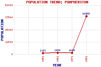
Pumpherston Classification and Statistics Settlement Type: village Population (1981): 38955 (Combined with Livingston) (1971): 1644 (1961): 1458 (1951): 1193 Tourist Rating: N/A Text of Entry Updated: 28-MAR-2019 Location Latitude: 55.9096°N Longitude: 3.4812°W National Grid Reference: NT 075 695 A range of modern and historical maps are accessible through the map tab on the right of this page Get directions by entering the UK postcode of your location, home or hotel here eg. EH1 3YT Use the tabs on the right of this page to see other parts of this entry Related Entries There are 15 related entries. (0 Attractions, 1 Council Area, 1 Historical County, 5 Features, 1 Parish, 1 Person and 6 Settlements) Names that are not linked do not currently contain any information. Council Area: West Lothian Features: Camps Viaduct Drumshoreland Bing Houstoun Industrial Estate Illieston Castle Pumpherston Golf Club Historical Counties: Midlothian Parishes: Mid Calder People: James Bryson Settlements: Livingston Lookaboutye Mid Calder Uphall Uphall Station Woolfords
There are 15 related entries. (0 Attractions, 1 Council Area, 1 Historical County, 5 Features, 1 Parish, 1 Person and 6 Settlements)
Names that are not linked do not currently contain any information.
By using our site you agree to accept cookies, which help us serve you better