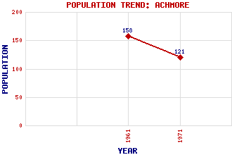
Achmore (Acha Mòr) Classification and Statistics Settlement Type: village Population (1971): 121 (1961): 158 Tourist Rating: No Text of Entry Updated: 30-APR-2020 Location Latitude: 58.1679°N Longitude: 6.5675°W National Grid Reference: NB 315 289 A range of modern and historical maps are accessible through the map tab on the right of this page Get directions by entering the UK postcode of your location, home or hotel here eg. EH1 3YT Use the tabs on the right of this page to see other parts of this entry Related Entries There are 12 related entries. (1 Attraction, 1 Council Area, 1 Historical County, 4 Features, 1 Parish, 0 People and 4 Settlements) Names that are not linked do not currently contain any information. Attractions: Achmore Stone Circle Council Area: Western Isles Features: Eitshal Lewis Oidraval Uraval, Loch Historical Counties: Ross and Cromarty Parishes: Lochs Settlements: Callanish Carloway Lochganvich Stornoway
There are 12 related entries. (1 Attraction, 1 Council Area, 1 Historical County, 4 Features, 1 Parish, 0 People and 4 Settlements)
Names that are not linked do not currently contain any information.
By using our site you agree to accept cookies, which help us serve you better