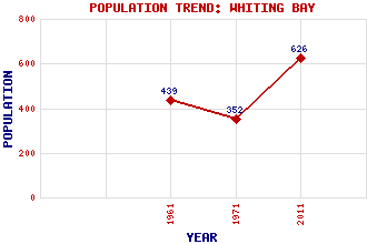
Whiting Bay Classification and Statistics Settlement Type: village Population (2011): 626 (1971): 352 (1961): 439 Tourist Rating: Yes Text of Entry Updated: 12-FEB-2004 Location Latitude: 55.4868°N Longitude: 5.0957°W National Grid Reference: NS 045 258 A range of modern and historical maps are accessible through the map tab on the right of this page Get directions by entering the UK postcode of your location, home or hotel here eg. EH1 3YT Use the tabs on the right of this page to see other parts of this entry Related Entries There are 15 related entries. (3 Attractions, 1 Council Area, 1 Historical County, 5 Features, 1 Parish, 0 People and 4 Settlements) Names that are not linked do not currently contain any information. Attractions: Arran Giants' Graves Glenashdale Falls Council Area: North Ayrshire Features: Cnoc na Garbad Garbad, Loch Holy Island Whiting Bay Whiting Bay Golf Club Historical Counties: Bute and Arran Parishes: Kilbride Settlements: Brodick Kildonan Lamlash Saltcoats
There are 15 related entries. (3 Attractions, 1 Council Area, 1 Historical County, 5 Features, 1 Parish, 0 People and 4 Settlements)
Names that are not linked do not currently contain any information.
By using our site you agree to accept cookies, which help us serve you better