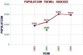
Sauchie (New Sauchie) Classification and Statistics Settlement Type: small town Population (1991): 5910 (1971): 6082 (1961): 4473 (1951): 3783 (1881): 2935 Tourist Rating: No Text of Entry Updated: 23-JUL-2019 Location Latitude: 56.1277°N Longitude: 3.7728°W National Grid Reference: NS 899 942 A range of modern and historical maps are accessible through the map tab on the right of this page Get directions by entering the UK postcode of your location, home or hotel here eg. EH1 3YT Use the tabs on the right of this page to see other parts of this entry Related Entries There are 15 related entries. (3 Attractions, 1 Council Area, 1 Historical County, 1 Family, 2 Features, 1 Parish, 2 People and 4 Settlements) Names that are not linked do not currently contain any information. Attractions: Gartmorn Dam Gartmorn Dam Country Park Sauchie Tower Council Area: Clackmannanshire Families: Shaw Features: Gartmorn Forest Lochies School Historical Counties: Clackmannanshire Parishes: Alloa People: David Henderson William Schaw Settlements: Alloa Alva Coalsnaughton Tillicoultry
There are 15 related entries. (3 Attractions, 1 Council Area, 1 Historical County, 1 Family, 2 Features, 1 Parish, 2 People and 4 Settlements)
Names that are not linked do not currently contain any information.
By using our site you agree to accept cookies, which help us serve you better