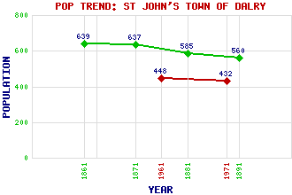
St John's Town of Dalry (Dalry, St John's Clachan of Dalry) Classification and Statistics Settlement Type: village Population (1971): 432 (1961): 448 (1891): 560 (1881): 585 (1871): 637 (1861): 639 Tourist Rating: Text of Entry Updated: 27-MAY-2013 Location Latitude: 55.1069°N Longitude: 4.16°W National Grid Reference: NX 623 813 A range of modern and historical maps are accessible through the map tab on the right of this page Get directions by entering the UK postcode of your location, home or hotel here eg. EH1 3YT Use the tabs on the right of this page to see other parts of this entry Related Entries There are 42 related entries. (2 Attractions, 1 Council Area, 1 Historical County, 1 Family, 27 Features, 1 Parish, 2 People and 7 Settlements) Names that are not linked do not currently contain any information. Attractions: Earlstoun Castle Southern Upland Way Council Area: Dumfries and Galloway Families: Gordon Features: Ardoch Hill Benbrack Beninner Benneeve Corse Hill Corseglass Hill Craigengillan Hill Craiglee Dalry School Dalry, Holm of Earlston House Earlstoun Earlstoun Loch Fell Hill Glenlee Hill Glenlee Power Station Howie, Loch Ken, Water of Knockman Hill Knockman Loch Knocknalling Lochinvar Luskie Dam Milldown Minnoch, Loch Moorbrock Hill Polharrow Burn Historical Counties: Kirkcudbrightshire Parishes: Dalry People: Neil Gunn Rev David Landsborough Settlements: Blawquhairn Bogue Corseglass Dundeugh Earlston Kendoon New Galloway
There are 42 related entries. (2 Attractions, 1 Council Area, 1 Historical County, 1 Family, 27 Features, 1 Parish, 2 People and 7 Settlements)
Names that are not linked do not currently contain any information.
By using our site you agree to accept cookies, which help us serve you better