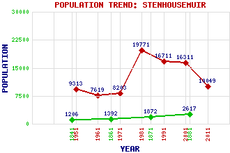
Stenhousemuir Classification and Statistics Settlement Type: small town Population (2011): 10049 (2001): 16311 (1991): 16711 (1981): 19771(Combined with Carron and Larbert) (1971): 8203 (1961): 7619 (1951): 9313 (1881): 2617 (1871): 1872 (1861): 1392 (1841): 1206 Tourist Rating: No Text of Entry Updated: 16-DEC-2008 Location Latitude: 56.0293°N Longitude: 3.8036°W National Grid Reference: NS 877 833 A range of modern and historical maps are accessible through the map tab on the right of this page Get directions by entering the UK postcode of your location, home or hotel here eg. EH1 3YT References and Further Reading Jaques, Richard (2001) Falkirk and District: An Illustrated Architectural Guide. The Rutland Press, Edinburgh Use the tabs on the right of this page to see other parts of this entry Related Entries There are 25 related entries. (2 Attractions, 1 Council Area, 1 Historical County, 1 Family, 8 Features, 1 Parish, 1 Person and 10 Settlements) Names that are not linked do not currently contain any information. Attractions: Falkirk Tryst Golf Course Ochilview Park Council Area: Falkirk Families: Stenhouse Features: Bellsdyke Hospital Carron Harbour Carron, River Carrongrange School Kinnaird House Larbert High School Penicuik House Plane Castle Historical Counties: Stirlingshire Parishes: Larbert People: Samuel Garbett Settlements: Airth Antonshill Carron Carronshore Denny Dunipace Falkirk Larbert Skinflats Torwood
There are 25 related entries. (2 Attractions, 1 Council Area, 1 Historical County, 1 Family, 8 Features, 1 Parish, 1 Person and 10 Settlements)
Names that are not linked do not currently contain any information.
By using our site you agree to accept cookies, which help us serve you better