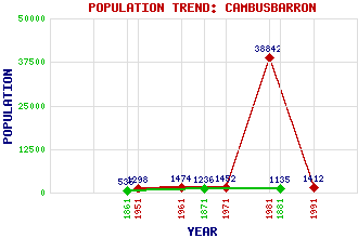
Cambusbarron Classification and Statistics Settlement Type: village Population (1991): 1412 (1981): 38842(Combined with Stirling) (1971): 1452 (1961): 1474 (1951): 1298 (1881): 1135 (1871): 1236 (1861): 535 Tourist Rating: No Text of Entry Updated: 12-JUN-2007 Location Latitude: 56.1086°N Longitude: 3.9681°W National Grid Reference: NS 777 924 A range of modern and historical maps are accessible through the map tab on the right of this page Get directions by entering the UK postcode of your location, home or hotel here eg. EH1 3YT Use the tabs on the right of this page to see other parts of this entry Related Entries There are 15 related entries. (1 Attraction, 1 Council Area, 1 Historical County, 4 Features, 1 Parish, 2 People and 5 Settlements) Names that are not linked do not currently contain any information. Attractions: Bannockburn Battlefield Council Area: Stirling Features: Gillies Hill North Third Reservoir Polmaise Castle Touch Hills Historical Counties: Stirlingshire Parishes: St Ninians People: King Robert I(Robert the Bruce) Alison Sheppard Settlements: Chartershall Gargunnock North Third Stirling Torbrex
There are 15 related entries. (1 Attraction, 1 Council Area, 1 Historical County, 4 Features, 1 Parish, 2 People and 5 Settlements)
Names that are not linked do not currently contain any information.
By using our site you agree to accept cookies, which help us serve you better