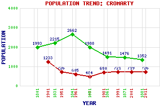
Cromarty Classification and Statistics Settlement Type: village Population (2011): 726 (2001): 719 (1991): 721 (1981): 690 (1971): 484 (1961): 605 (1951): 726 (1901): 1233(Parliamentary and Municipal Burgh) (1881): 1352 (1871): 1476 (1861): 1491 (1851): 1988 (1841): 2662 (1831): 2215 (1801): 1993 Tourist Rating: Text of Entry Updated: 29-JUL-2006 Location Latitude: 57.68°N Longitude: 4.0374°W National Grid Reference: NH 786 674 A range of modern and historical maps are accessible through the map tab on the right of this page Get directions by entering the UK postcode of your location, home or hotel here eg. EH1 3YT References and Further Reading Beaton, Elizabeth (1992) Ross and Cromarty: An Illustrated Architectural Guide. The Royal Incorporation of Architects in Scotland, Edinburgh Use the tabs on the right of this page to see other parts of this entry Related Entries There are 34 related entries. (3 Attractions, 1 Council Area, 1 Historical County, 1 Family, 6 Features, 1 Parish, 11 People and 10 Settlements) Names that are not linked do not currently contain any information. Attractions: Cromarty Courthouse Museum Cromarty East Church Hugh Miller's Cottage Council Area: Highland Families: Urquhart Features: Black Isle Cromarty Cromarty Bay Cromarty Firth Cromarty House Gallow Hill Historical Counties: Ross and Cromarty Parishes: Cromarty People: Andrew Carnegie Don Coutts Alan Grant Donald MacKenzie David John Maclean(Lord Blencathra) Hugh Miller Sir William Pulteney(William Johnstone) George Ross James Thomson David Urquhart Sir Thomas Urquhart Settlements: Balnapaling Culross Glenurquhart Hilton of Cadboll Inverness Navity Nigg Nigg Ferry Resolis Upper Eathie
There are 34 related entries. (3 Attractions, 1 Council Area, 1 Historical County, 1 Family, 6 Features, 1 Parish, 11 People and 10 Settlements)
Names that are not linked do not currently contain any information.
By using our site you agree to accept cookies, which help us serve you better