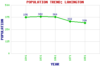
Lamington Classification and Statistics Settlement Type: village Population (1881): 316 (For parish) (1871): 332(For parish) (1861): 380(For parish) (1831): 382(For parish) (1801): 375(For parish) Tourist Rating: N/A Text of Entry Updated: 06-MAY-2019 Location Latitude: 55.5619°N Longitude: 3.6203°W National Grid Reference: NS 979 310 A range of modern and historical maps are accessible through the map tab on the right of this page Get directions by entering the UK postcode of your location, home or hotel here eg. EH1 3YT Use the tabs on the right of this page to see other parts of this entry Related Entries There are 13 related entries. (0 Attractions, 1 Council Area, 1 Historical County, 9 Features, 1 Parish, 0 People and 1 Settlement) Names that are not linked do not currently contain any information. Council Area: South Lanarkshire Features: Clyde, River Cowgill Loch Cowgill Lower Reservoir Cowgill Upper Reservoir Holy Trinity Church Lamington Bridge Lamington Burn Lamington Viaduct West Coast Main Line Historical Counties: Lanarkshire Parishes: Lamington and Wandel Settlements: Biggar
There are 13 related entries. (0 Attractions, 1 Council Area, 1 Historical County, 9 Features, 1 Parish, 0 People and 1 Settlement)
Names that are not linked do not currently contain any information.
By using our site you agree to accept cookies, which help us serve you better