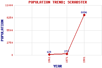
Scrabster Classification and Statistics Settlement Type: village Population (1981): 8896 (Combined with Thurso) (1971): 273 (1961): 129 Tourist Rating: No Text of Entry Updated: 04-JUN-2006 Location Latitude: 58.6094°N Longitude: 3.5507°W National Grid Reference: ND 100 701 A range of modern and historical maps are accessible through the map tab on the right of this page Get directions by entering the UK postcode of your location, home or hotel here eg. EH1 3YT Use the tabs on the right of this page to see other parts of this entry Related Entries There are 19 related entries. (1 Attraction, 1 Council Area, 1 Historical County, 12 Features, 1 Parish, 1 Person and 2 Settlements) Names that are not linked do not currently contain any information. Attractions: Hamnavoe Council Area: Highland Features: A9 Trunk Road Caithness Clett Far North Line Holborn Head Holburn Head Lighthouse Litter, Ness of Orkney Islands Pentland Firth Spear Head Thurso Bay Thurso Railway Station Historical Counties: Caithness Parishes: Thurso People: George Bain Settlements: Halkirk Thurso
There are 19 related entries. (1 Attraction, 1 Council Area, 1 Historical County, 12 Features, 1 Parish, 1 Person and 2 Settlements)
Names that are not linked do not currently contain any information.
By using our site you agree to accept cookies, which help us serve you better