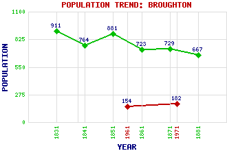
Broughton Classification and Statistics Settlement Type: village Population (1971): 182 (1961): 154 (1881): 667 (1871): 729 (1861): 723 (1851): 881 (1841): 764 (1831): 911 Tourist Rating: Text of Entry Updated: 31-MAR-2022 Location Latitude: 55.6157°N Longitude: 3.4114°W National Grid Reference: NT 112 367 A range of modern and historical maps are accessible through the map tab on the right of this page Get directions by entering the UK postcode of your location, home or hotel here eg. EH1 3YT Use the tabs on the right of this page to see other parts of this entry Related Entries There are 36 related entries. (1 Attraction, 1 Council Area, 1 Historical County, 16 Features, 1 Parish, 4 People and 12 Settlements) Names that are not linked do not currently contain any information. Attractions: John Buchan Way Council Area: Scottish Borders Features: Biggar Water Blakehope Head Broomy Law Broughton Place Common Law Coomb Hill Devil's Beef Tub Drumelzier Castle Green Law Hunt Law Knowe Kniffling Long Grain Knowe Penvalla Trahenna Hill Tweeddale Worm Hill Historical Counties: Peeblesshire Parishes: Broughton, Glenholm & Kilbucho People: John Buchan(1st Baron Tweedsmuir) Sir John Murray of Broughton Sir Basil Urwin Spence Prince Charles Edward Stuart(Bonnie Prince Charlie) Settlements: Biggar Cambuswallace Causewayend Drumelzier Elsrickle Glenholm Kilbucho Peebles Rachan Mill Skirling Stobo Tweedsmuir
There are 36 related entries. (1 Attraction, 1 Council Area, 1 Historical County, 16 Features, 1 Parish, 4 People and 12 Settlements)
Names that are not linked do not currently contain any information.
By using our site you agree to accept cookies, which help us serve you better