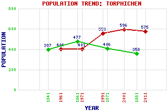
Torphichen Classification and Statistics Settlement Type: village Population (2011): 575 (2001): 596 (1991): 559 (1971): 401 (1961): 404 (1881): 358 (1871): 406 (1861): 477 (1841): 397 Tourist Rating: Text of Entry Updated: 24-FEB-2014 Location Latitude: 55.9335°N Longitude: 3.655°W National Grid Reference: NS 967 724 A range of modern and historical maps are accessible through the map tab on the right of this page Get directions by entering the UK postcode of your location, home or hotel here eg. EH1 3YT Use the tabs on the right of this page to see other parts of this entry Related Entries There are 24 related entries. (5 Attractions, 1 Council Area, 1 Historical County, 10 Features, 1 Parish, 3 People and 3 Settlements) Names that are not linked do not currently contain any information. Attractions: Cairnpapple Hill Knock, The Scottish Korean War Memorial Torphichen Preceptory Witchcraig Wood and Riding Area Council Area: West Lothian Features: Bathgate Hills Bowden Hill Caribber Reservoir Cockleroy Hill Cow Hill Gormyre Stone Lochcote Reservoir Refuge Stane Torphichen Hills Wallhouse Historical Counties: West Lothian Parishes: Torphichen People: William Maxwell Aitken(1st Lord Beaverbrook) Henry Bell Sir James Gowans Settlements: Bathgate Kipps Lochcote
There are 24 related entries. (5 Attractions, 1 Council Area, 1 Historical County, 10 Features, 1 Parish, 3 People and 3 Settlements)
Names that are not linked do not currently contain any information.
By using our site you agree to accept cookies, which help us serve you better