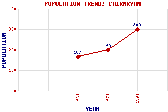
Cairnryan (Macherie) Classification and Statistics Settlement Type: village Population (1991): 300 (1971): 199 (1961): 167 Tourist Rating: N/A Text of Entry Updated: 19-DEC-2014 Location Latitude: 54.9751°N Longitude: 5.0296°W National Grid Reference: NX 062 687 A range of modern and historical maps are accessible through the map tab on the right of this page Get directions by entering the UK postcode of your location, home or hotel here eg. EH1 3YT Use the tabs on the right of this page to see other parts of this entry Related Entries There are 39 related entries. (1 Attraction, 1 Council Area, 1 Historical County, 32 Features, 1 Parish, 0 People and 3 Settlements) Names that are not linked do not currently contain any information. Attractions: Devil's Porridge, The Council Area: Dumfries and Galloway Features: A77 Trunk Road Braid Fell Cairn Hill Cairn Point Cairnerzean Fell Diddles Hill Doon, Loch Drumacissock Drumadryland Finnarts Hill Finnarts Point High Murdonochee Laird's Hill Lamb Hill Leffnoll Point Liggat Hill Loch Doon Hill Loch Ryan Lighthouse Lochryan House Mark Hill Mid Hill Old House Point Penwhirn Burn Penwhirn Reservoir Ree, Loch Ryan, Loch South Moile Stab Hill Stranraer Railway Station Superior, Lake Turf Hill White Hill Historical Counties: Wigtownshire Parishes: Inch Settlements: Laight Marchburn Stranraer
There are 39 related entries. (1 Attraction, 1 Council Area, 1 Historical County, 32 Features, 1 Parish, 0 People and 3 Settlements)
Names that are not linked do not currently contain any information.
By using our site you agree to accept cookies, which help us serve you better