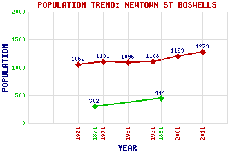
Newtown St Boswells Classification and Statistics Settlement Type: settlement Population (2011): 1279 (2001): 1199 (1991): 1108 (1981): 1095 (1971): 1101 (1961): 1052 (1881): 444 (1871): 302 Tourist Rating: No Text of Entry Updated: 27-JUL-2019 Location Latitude: 55.5753°N Longitude: 2.674°W National Grid Reference: NT 576 315 A range of modern and historical maps are accessible through the map tab on the right of this page Get directions by entering the UK postcode of your location, home or hotel here eg. EH1 3YT Use the tabs on the right of this page to see other parts of this entry Related Entries There are 23 related entries. (4 Attractions, 1 Council Area, 1 Historical County, 8 Features, 1 Parish, 2 People and 6 Settlements) Names that are not linked do not currently contain any information. Attractions: Bemersyde House Borders Railway Cessford Castle Scott's View Council Area: Scottish Borders Features: Borders College Eildon Hall Eildon Hills Lauderdale Scottish Borders Campus Scottish Borders Council Offices (Peebles) Tweed Horizons Tweed, River Historical Counties: Roxburghshire Parishes: Melrose People: Lady Grisell Baillie Saint Boswell(St. Boswell, St. Boisil, St. Bosiel) Settlements: Bemersyde Bowden Camieston Melrose Smailholm St Boswells
There are 23 related entries. (4 Attractions, 1 Council Area, 1 Historical County, 8 Features, 1 Parish, 2 People and 6 Settlements)
Names that are not linked do not currently contain any information.
By using our site you agree to accept cookies, which help us serve you better