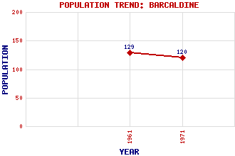
Barcaldine Classification and Statistics Settlement Type: village Population (1971): 120 (1961): 129 Tourist Rating: N/A Text of Entry Updated: 01-AUG-2019 Location Latitude: 56.522°N Longitude: 5.3196°W National Grid Reference: NM 959 416 A range of modern and historical maps are accessible through the map tab on the right of this page Get directions by entering the UK postcode of your location, home or hotel here eg. EH1 3YT Use the tabs on the right of this page to see other parts of this entry Related Entries There are 12 related entries. (1 Attraction, 1 Council Area, 1 Historical County, 1 Family, 7 Features, 1 Parish, 0 People and 0 Settlements) Names that are not linked do not currently contain any information. Attractions: Barcaldine Forest Council Area: Argyll and Bute Families: Campbell Features: Barcaldine Castle Benderloch Station Creran, Loch Dearg Abhainn Dubh, Gleann Salach, Glen Teithil, Abhainn Historical Counties: Argyllshire Parishes: Ardchattan and Muckairn
There are 12 related entries. (1 Attraction, 1 Council Area, 1 Historical County, 1 Family, 7 Features, 1 Parish, 0 People and 0 Settlements)
Names that are not linked do not currently contain any information.
By using our site you agree to accept cookies, which help us serve you better