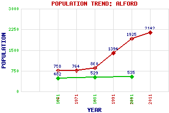
Alford Classification and Statistics Settlement Type: village Population (2011): 2142 (2001): 1925 (1991): 1394 (1981): 860 (1971): 764 (1961): 758 (1891): 535 (1881): 529 (1871): 482 Tourist Rating: N/A Text of Entry Updated: 24-MAY-2019 Location Latitude: 57.2345°N Longitude: 2.7023°W National Grid Reference: NJ 577 162 A range of modern and historical maps are accessible through the map tab on the right of this page Get directions by entering the UK postcode of your location, home or hotel here eg. EH1 3YT Use the tabs on the right of this page to see other parts of this entry Related Entries There are 48 related entries. (7 Attractions, 1 Council Area, 1 Historical County, 17 Features, 1 Parish, 7 People and 14 Settlements) Names that are not linked do not currently contain any information. Attractions: Alford Dry Ski Slope Alford Heritage Centre Alford Valley Railway Balfluig Castle Craigievar Castle Grampian Transport Museum Haughton Country Park Council Area: Aberdeenshire Features: Aberdeen-Inverness Line Airlie, Hill of Alford Academy Alford Battlefield Alford Golf Club Benaquhallie Black Hill Callievar Hill Correen Hills Don, River Howe of Alford Howe of Cushnie Lang Stane Lord Arthur's Hill Millmedden, Hill of Mither Tap Tanshall Historical Counties: Aberdeenshire Parishes: Alford People: Robert Davidson Helen Denerley Sir Ewan Forbes of Craigievar William McCombie Charles Murray Margaret Myles Emeli Sandé(Adele Emeli Sandé Gouraguine) Settlements: Aberdeen Bridge of Alford Glenkindie Keig Kildrummy Leochel-Cushnie Milton of Cushnie Montgarrie Mossat Rhynie Tillyfour Tillyfourie Tullynessle Whitehouse
There are 48 related entries. (7 Attractions, 1 Council Area, 1 Historical County, 17 Features, 1 Parish, 7 People and 14 Settlements)
Names that are not linked do not currently contain any information.
By using our site you agree to accept cookies, which help us serve you better