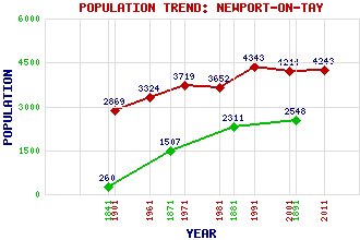
Newport-on-Tay Classification and Statistics Settlement Type: village Population (2011): 4243 (Combined with Wormit) (2001): 4214 (1991): 4343 (1981): 3652 (1971): 3719 (1961): 3324 (1901): 2869(Police Burgh) (1891): 2548 (1881): 2311 (1871): 1507 (1841): 260 Tourist Rating: Text of Entry Updated: 07-SEP-2013 Location Latitude: 56.4415°N Longitude: 2.9406°W National Grid Reference: NO 421 281 A range of modern and historical maps are accessible through the map tab on the right of this page Get directions by entering the UK postcode of your location, home or hotel here eg. EH1 3YT Use the tabs on the right of this page to see other parts of this entry Related Entries There are 35 related entries. (1 Attraction, 1 Council Area, 1 Historical County, 5 Features, 16 Parishes, 6 People and 5 Settlements) Names that are not linked do not currently contain any information. Attractions: Fife Coastal Path Council Area: Fife Features: Craig Law Dundee Harbour Tay Bridge Tay Road Bridge Tay, Firth of Historical Counties: Fife Parishes: Auchterhouse Balmerino Dundee Dundee Combination Ferry Port on Craig Forgan Fowlis Easter Kilmany Leuchars Liff and Benvie Logie Longforgan Mains and Strathmartine Murroes St Andrews and St Leonards Tealing People: Sir Thomas Bouch Thomas Symington Halliday(T.S. Halliday) William (Billy) Kay Alexander Sutherland Neill(A.S. Neill) William Robertson Thomas Telford Settlements: Dundee Pickletillem Washer Willy's Woodhaven Wormit
There are 35 related entries. (1 Attraction, 1 Council Area, 1 Historical County, 5 Features, 16 Parishes, 6 People and 5 Settlements)
Names that are not linked do not currently contain any information.
By using our site you agree to accept cookies, which help us serve you better