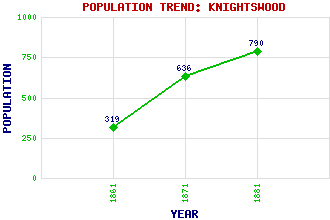
Knightswood Classification and Statistics Settlement Type: suburb Population (1881): 790 (1871): 636 (1861): 319 Tourist Rating: No Text of Entry Updated: 10-NOV-2018 Location Latitude: 55.8935°N Longitude: 4.3474°W National Grid Reference: NS 533 692 A range of modern and historical maps are accessible through the map tab on the right of this page Get directions by entering the UK postcode of your location, home or hotel here eg. EH1 3YT References and Further Reading Williamson, Elizabeth, Anne Riches and Malcolm Higgs (1990) The Buildings of Scotland: Glasgow. Penguin, London Use the tabs on the right of this page to see other parts of this entry Related Entries There are 14 related entries. (1 Attraction, 1 Council Area, 1 Historical County, 3 Features, 1 Parish, 2 People and 5 Settlements) Names that are not linked do not currently contain any information. Attractions: Knightswood Park Council Area: Glasgow City Features: Knightswood Golf Course Knightswood Secondary School Westerton Railway Station Historical Counties: Dunbartonshire Parishes: New Kilpatrick People: Alexander (Alex) Duff Ethel MacDonald Settlements: Anniesland Drumchapel Garscadden Glasgow Jordanhill
There are 14 related entries. (1 Attraction, 1 Council Area, 1 Historical County, 3 Features, 1 Parish, 2 People and 5 Settlements)
Names that are not linked do not currently contain any information.
By using our site you agree to accept cookies, which help us serve you better