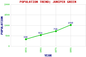
Juniper Green Classification and Statistics Settlement Type: suburb Population (1881): 1018 (1871): 716 (1861): 531 (1831): 338 Tourist Rating: No Text of Entry Updated: 19-OCT-2020 Location Latitude: 55.9037°N Longitude: 3.2875°W National Grid Reference: NT 196 686 A range of modern and historical maps are accessible through the map tab on the right of this page Get directions by entering the UK postcode of your location, home or hotel here eg. EH1 3YT References and Further Reading Cant, Malcolm (1999) Villages of Edinburgh: An Illustrated Guide. Malcolm Cant Publications, Edinburgh Use the tabs on the right of this page to see other parts of this entry Related Entries There are 20 related entries. (3 Attractions, 1 Council Area, 1 Historical County, 7 Features, 1 Parish, 2 People and 5 Settlements) Names that are not linked do not currently contain any information. Attractions: Colinton Tunnel Dr MacKay's Wood Water of Leith Walkway Council Area: City of Edinburgh Features: Baberton Baberton House Corby Hill Edinburgh Bypass Leith, Water of Torduff Reservoir Torphin Hill Historical Counties: Midlothian Parishes: Edinburgh People: William Ewart Gladstone Sir Matthew Ochterlony Settlements: Balerno Colinton Currie Edinburgh Slateford
There are 20 related entries. (3 Attractions, 1 Council Area, 1 Historical County, 7 Features, 1 Parish, 2 People and 5 Settlements)
Names that are not linked do not currently contain any information.
By using our site you agree to accept cookies, which help us serve you better