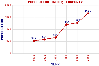
Luncarty Classification and Statistics Settlement Type: village Population (2011): 1661 (2001): 1265 (1991): 1190 (1981): 664 (1971): 584 (1961): 519 Tourist Rating: N/A Text of Entry Updated: 05-MAY-2020 Location Latitude: 56.4489°N Longitude: 3.4697°W National Grid Reference: NO 095 295 A range of modern and historical maps are accessible through the map tab on the right of this page Get directions by entering the UK postcode of your location, home or hotel here eg. EH1 3YT Use the tabs on the right of this page to see other parts of this entry Related Entries There are 17 related entries. (1 Attraction, 1 Council Area, 1 Historical County, 7 Features, 1 Parish, 1 Person and 5 Settlements) Names that are not linked do not currently contain any information. Attractions: Over Benchil Standing Stone Council Area: Perth and Kinross Features: A9 Trunk Road Benchil Burn Highland Line Ordie Burn Shochie Burn Strathord Tay, River Historical Counties: Perthshire Parishes: Redgorton People: Saint Fillan(St. Fillan) Settlements: Battleby Benchil Colenden Downhill Perth
There are 17 related entries. (1 Attraction, 1 Council Area, 1 Historical County, 7 Features, 1 Parish, 1 Person and 5 Settlements)
Names that are not linked do not currently contain any information.
By using our site you agree to accept cookies, which help us serve you better