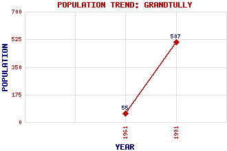
Grandtully Classification and Statistics Settlement Type: settlement Population (1991): 507 (1961): 55 Tourist Rating: N/A Text of Entry Updated: 19-APR-2011 Location Latitude: 56.6561°N Longitude: 3.7747°W National Grid Reference: NN 913 529 A range of modern and historical maps are accessible through the map tab on the right of this page Get directions by entering the UK postcode of your location, home or hotel here eg. EH1 3YT Use the tabs on the right of this page to see other parts of this entry Related Entries There are 15 related entries. (1 Attraction, 1 Council Area, 1 Historical County, 1 Event, 1 Family, 5 Features, 1 Parish, 1 Person and 3 Settlements) Names that are not linked do not currently contain any information. Attractions: Griffin Forest Council Area: Perth and Kinross Events: Reformation, The Families: Stewart Features: Duin, Loch an Grandtully Castle Murthly Castle Tay, River Tay, Strath Historical Counties: Perthshire Parishes: Logierait People: Alexander Stewart(Earl of Buchan, Wolf of Badenoch) Settlements: Aberfeldy Ballinluig Pitcairn
There are 15 related entries. (1 Attraction, 1 Council Area, 1 Historical County, 1 Event, 1 Family, 5 Features, 1 Parish, 1 Person and 3 Settlements)
Names that are not linked do not currently contain any information.
By using our site you agree to accept cookies, which help us serve you better