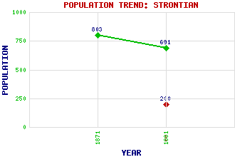
Strontian Classification and Statistics Settlement Type: hamlet Population (1991): 200 (1881): 691 (1871): 803 Tourist Rating: N/A Text of Entry Updated: 17-JUL-2006 Location Latitude: 56.6948°N Longitude: 5.5717°W National Grid Reference: NM 814 616 A range of modern and historical maps are accessible through the map tab on the right of this page Get directions by entering the UK postcode of your location, home or hotel here eg. EH1 3YT Use the tabs on the right of this page to see other parts of this entry Related Entries There are 33 related entries. (1 Attraction, 1 Council Area, 1 Historical County, 21 Features, 1 Parish, 1 Person and 7 Settlements) Names that are not linked do not currently contain any information. Attractions: Ariundle Oakwoods National Nature Reserve Council Area: Highland Features: Ardnamurchan Ardnamurchan High School Beinn Mheadhoin Carnoch River Chothruim, Lochan a' Chothruim, Lochan a' Doilet, Loch Druim Min Garbh Bheinn Meall a Chuilinn Mor, Eilean Sgurr Dhomhnuill Sgurr a' Chaorainn Sgurr na h-Ighinn Sgurr nan Cnamh Sron na Saobhaidh Strontian Lead Mines Strontian River Sunart Sunart, Loch Taobh Dubh Historical Counties: Argyllshire Parishes: Ardnamurchan People: Prof. Thomas Charles Hope Settlements: Achnalea Anaheilt Ardnastang Inversanda Liddesdale Scotstown Woodend
There are 33 related entries. (1 Attraction, 1 Council Area, 1 Historical County, 21 Features, 1 Parish, 1 Person and 7 Settlements)
Names that are not linked do not currently contain any information.
By using our site you agree to accept cookies, which help us serve you better